-
October 20 - Fairview to Ridgecrest

A Canyon at the Start of the Climb

Rick Coming Around One of the Switchbacks

Jim and Me at the Summit

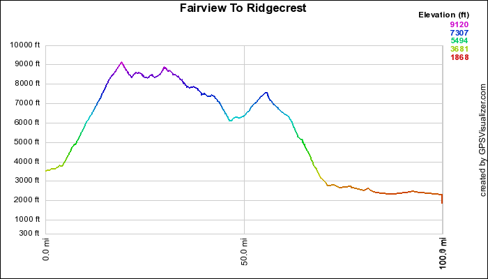
The Day's Elevation Profile
Please visit October 20 slideshow.
Day 2 started out cool and clear. After loading up with breakfast at Cheryl's Diner, we packed up the sags. The ride officially started in Fairview - 15 miles up the road. Several riders decided to cycle this part of the ride to add to the advertised 95-mile day. I rode with Dennis to Fairview and I'm glad I did. These first few miles followed the Kern River on a well-paved, scenic road. It added about 1200 feet of daily elevation gain.
I got on the road at about 9:30. I rode for four miles and made the sharp right turn onto the Sherman Pass Road and immediately started climbing. The climb was relentless. It went for 15 miles until we reached the summit. The elevation gain was around 5700 feet to the top at 9100 feet. There were no "walls", just steady ups. Relief was in the form of some short 4-5% stretches, sag stops and photo ops. It started warming up during the climb and I had to shed some outerwear.
We stopped at the summit for a few minutes to take some pictures and to eat some snacks. (Lunch was farther down the road). It was cold at this elevation, so I put my jacket back on for the ride to lunch. I started downhill and saw snow on the left-hand side of the road. I knew I was in for a cold descent. Not only was it cool, but the wind started howling. There were a couple of spots where it slowed me almost to a stop. The wind plus several short uphill stretches really took all of my energy. I crawled into the sag about five miles short of lunch.
Lunch was at the side of the road at around 8500 feet. It was a real alpine area with lots of trees. It felt good to refuel, but my legs were in no shape to continue. So I stayed in the sag for the rest of the ride.
The route had some downs and ups for the next several miles. It went through beautiful Kennedy Meadows and began climbing again. We picked up several riders at this point, but the hard-core cyclists continued on. After the Kennedy Meadows climb, the trees disappeared, the hills became barren and the riders reached an amazing downhill through Nine Mile Canyon to the desert floor. At the intersection with Hwy 395, we picked up more riders. Others rode on for another 20 miles through the desert alternately being chased by strong tailwinds and being tossed around by gusty sidewinds. We all arrived at the Econo Lodge in Ridgecrest at about the same time. My final statistics were 30 miles and 6000 feet of climbing. The riders that did the whole route got 110 miles and 10,000 feet of climbing.
After a shower and several beers, we headed out to the Texas Cattle Company. Being a non red meat person, I opted for barbequed chicken. Others had steak or prime rib. We shared the wine.
The map of our route is below. To see it in Google Earth, follow this link.
 Bob on Pedal the Peaks
2007
